news details |
|
|
| 2ND MAHARAJA of J&K GAVE AKSAI CHIN TO INDIA | | | 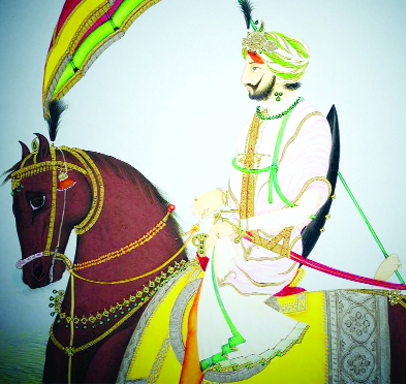
Th. K P Singh
Maharaja Gulab Singh was the founder of a vast empire in North India spanning over 86 thousand sq miles, nearly half of which lies under illegal occupation of China and Pakistan since independence. Jammu became vassal state of Punjab in 1808 and Kashmir was conquered by Sikhs from Afghans in 1819. For the remarkable services rendered to Lahore Darbar by Dogra General of Sikh Army Gulab Singh in all the major campaigns, Maharaja Ranjit Singh anointed him as ruler of Jammu in 1822. With Jammu as firm base, Raja Gulab Singh rapidly proceeded to build up an empire by conquering Ladakh in 1830s, Gilgit-Baltistan & other principalities of Dardistan and Western Tibet in 1840s.
In 1846, after defeat in Anglo-Sikh War, Lahore Darbar ceded Kashmir to East India Company against war indemnity. It was granted to Raja Gulab Singh by Lord Henry Hardinge, the Governor, for Rs 75 lakh through the Treaty of Amritsar dated 16 March 1846. By 1850s Gulab Singh had become the ruler of a vast empire whose boundaries touched the empires of Tibet, China, Afghanistan, NWFP and nearly touched Russia through narrow Wakhan Corridor of Afghanistan. It however didn’t include areas across Karakoram Range where Aksai Chin falls.
British exploration of Maharaja Gulab Singh’s hinterland dominions began immediately after signing of the Treaty of Amritsar. The main British interest at that time was the Eastern borders of Ladakh which Raja Gulab Singh had annexed in 1830s & 40s, then deemed by British to be in some way part of Chinese empire. Hence Govt of India dispatched a boundary commission to work out where exactly the limits of newly created Dogra empire were or should be. British members of Boundary Commission explored that border from Lahul to the mountains North of Pangong Tso and other frontier tracts of Dardistan up to Karakoram Pass and marked Karakoram Range as extent of Dogra rule.
In the 1860s British started taking more interest in Tzarist Imperialism getting alarmingly closer to Northern frontiers of J&K when Russia penetrated in Khanats of Khive, Kokand and Bokhara, (Bokhara the capital city of Bokhara Region of Uzbekistan) situated on the Silk Route in a rough triangle of Aral Sea, North of Afghanistan and West of Chinese Turkistan. Russians were seen fast approaching Chinese Turkistan when it looked as if Chinese rule over Central Asia would collapse to leave to what British perceived as an extremely dangerous power vacuum. By 1865 it was evident to the British strategists that security of the Northern frontiers either was being or would shortly be threatened.
The collapse of Wanchu domination in Chinese Turkistan began in 1861 when Muslims in Kansu rebelled thereby severing ‘line of communication’ between China and the vast area of Central Asia. Wanchu dynasty managed to survive this rebellion but when the uprising erupted in Central Asia, China ceased to be overlord of that region. There arose one chieftain Buzurg Khan who quickly established himself in Kashgaria with capital at Kashgar. He was replaced by Yakub Beg who consolidated his hold over Turkistan and extended his borders to mainland China and Mongolian borderlands along Altai mountains. Russians got interested in what was happening in the former Chinese dominion. They saw the prospects of possible annexation of Turkistan to touch J&K State boundaries meaning Indian Northern frontiers but that didn’t work out. When Yakub died in 1877, Kashgar was recaptured by Chinese and Turkistan declared as Sinkiang (Xinjiang) Province of metropolitan China. But it remained a zone of Chinese vulnerability and strategists in India anticipated that eventually it will become Russian territory/protectorate. It is against this background that the history of Northern frontiers must be examined.
Following ambitions of his illustrious father, Maharaja Ranbir Singh of J&K was quick to appreciate the significance of the change taking place to his North in Chinese Turkistan. The collapse of Chinese rule created a tempting opportunity for him to enlarge, if not its territorial extent at least its diplomatic and commercial influence. In 1864 he dispatched a composite garrison, sixty miles as the crow flies, North of Karakoram Pass to Shahidullah on the Caravan route from Leh to Kashgar where a military post and a Fort were established. At the same time he entered into a correspondence with Amir of Khotan, (now in Sinkiang Province) Haji Habibulla Khan, who had assumed power in the town in the absence of Chinese authority. In the quest of possible allies in turbulent and uncertain times, Amir of Khotan wrote to Maharaja Ranbir Singh to facilitate his direct contact with the govt of India. Maharaja saw that Amir’s overtures could well be exploited to the advantage of J&K. He wanted to expand his state’s territories and trade with Eastern Turkistan to protect it from bandit raids and to ensure that it was properly taxed to the benefit of his treasury. These were the major objectives of Shahidullah garrison.
In 1865 Maharaja Ranbir Singh managed to bring the govt of India into mapping of his Northern boundaries. The task was entrusted to W.H. Johnson, an embittered Surveyor who felt that British employers had not given his merit its due, perhaps because of his Eurasian ancestry. In return for the promise of future employment with the state, Johnson agreed to act in a diplomatic capacity on behalf of J&K State. (After his retirement Johnson was appointed Governor of Ladakh).
In 1865 Johnson crossed over from Leh to Khotan, following not the usual Karakoram Pass route but a path further to the East which ran across the high Aksai Chin wasteland on the edge of Tibetan Plateau and descended towards Khotan by way of Karakash River. There had been some use of this approach to the Tibetan Plateau from Chinese Turkistan side over the centuries because upper reaches of Karakash were a valuable source of Jade, a mineral much wanted in the China and it seemed that Amir Habibullah Khan had been trying to improve the way as an alternate to Karakoram Pass which he could use as his private access to India.
Johnson’s journey, from the point of view of J&K ruler, achieved three objectives. (i) It established contact between J&K and Khotan through what appeared to be through British official, which impressed the Amir. (ii) It explored a route which might, as Amir Habibullah had already concluded, turn out to be alternate way around 18,000 ft extremely high & difficult Karakoram Pass and during the times of Chinese control strongly guarded. It could be of use both for secret contacts, even for clandestine trade, if the Chinese ever came back to Turkistan. (iii) The resulting survey included a considerable tract of territory across Karakoram Range as part of J&K on the official British maps, which hitherto been out of the Maharaja’s dominion. Johnson maps showed Northeastern border of the state nearly hundred miles ahead of Karakoram Pass and far beyond the watershed into what had until then been, without doubt, Chinese territory. The results of Johnson survey was published in 1868 by Govt of India entitled ‘Kashmir Atlas’. This showed the State of J&K extending far to the North of Karakoram Pass and beyond Aksai Chin. It was calculated by one British observer that the boundary of J&K had been expanded by 21,000 sq miles. Hence the only survey available was Johnson Map which became an authority to lay the foundation for the post 1947 Indian claim to Aksai Chin. But no reference of British Maps, Maharaja Ranbir Singh or Dogra control is made while claiming Aksai Chin as Indian territory.
By 1959 possibility of any simple/theoretical solution to the Aksai-Chin problem such as modification of maps which may perhaps existed in 1956-57, had vanished without any hope. In 1959 there were armed clashes between Indian and Chinese patrols both in Ladakh and along the McMahon Line. These were the prelude to the greater crisis which was to erupt in 1962. It was the crisis which became closely involved with the Kashmir dispute.
On 9th November 1962, during a Parliamentary debate on 1962 War, opposition leader Atal Behari Vajpayee had said, “among other things, Chinese forces are still in occupation of Aksai Chin. Our stain, our humiliation and defeat will not be wiped out until we swept the last Chinese from our soil”. Thereafter a unanimous resolution was adopted by the Parliament on 14 November 1962 which pledged to get back the territory occupied by China to the last inch. Ironically no military preparations were made to do so. Illegally occupied territories of J&K remain subject matter of debates and declarations only, the consequences of which we are facing today in Northern frontiers.
On 5th August 2019, world heard Home Minister of India telling Parliament that Aksai Chin is an integral part of India and we will have it back. That further substantiated Indian claim over Aksai Chin. In the face of historical evidence of Aksai Chin having been part of Dogra Empire and acceded to India, China has no option but to vacate Aksai Chin.
Due credit must go to the brilliant strategy and diplomacy of Maharaja Ranbir Singh for extending Indian reach and claim over hundred plus miles ahead of Karakoram Range. And the Dogras must talk about it loudly. |
|
|
|
|
|
|
|
|
|
|
|
|
| |
| |
|
|
|
|
 |
|
|
|
|
STOCK UPDATE |
|
|
 |
| BSE
Sensex |
 |
| NSE
Nifty |
|
|
| |
CRICKET UPDATE |
|
|

|
|
| |
| |
|
|
| |
|
|
|
|
| |
|
|
|
|
|
|
|
|
|
|
|
|
|