news details |
|
|
| NFR leveraging modern technology for ensuring safety of Lumding - Badarpur Hill Section | | | 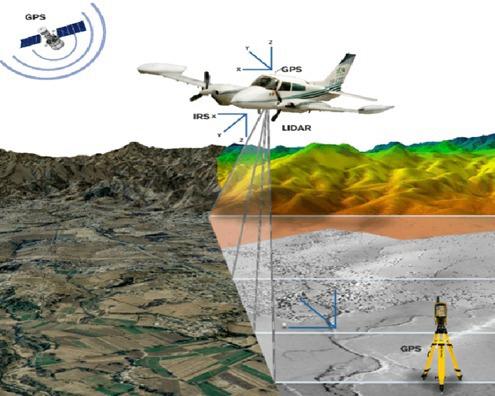 AGENCIES AGENCIES
MALIGAON, May 14: In a major step towards enhancing railway safety and infrastructure resilience, Northeast Frontier Railway (NFR) has deployed state-of-the-art technology to address challenges related to landslides, drainage issues and embankment stability along the Lumding-Badarpur Hill Section in Assam of Lumding division under NFR. This section, spanning hilly terrain across Dima Hasao and Cachar districts, is a vital link connecting the states of Tripura, Mizoram, Manipur and the Barak Valley of Assam with the rest of India. The difficult topography and extreme monsoon conditions make this route especially vulnerable to natural hazards, often disrupting rail traffic and posing significant safety risks.
To mitigate these challenges, NFR has initiated a comprehensive aerial and geophysical survey over an 80-kilometer stretch of the hill section, from KM-45 to KM-125. This initiative utilizes advanced drone-based LiDAR (Light Detection and Ranging), high-resolution aerial imaging and electromagnetic surveys. The survey captured 2 cm resolution LiDAR orthophotos, thermal imagery and Digital Elevation Models (DEMs), providing detailed insights into terrain morphology, slope stability and surface deformation. Complementing the aerial survey, Ground Penetrating Radar (GPR), Transient Electromagnetic Survey, Electrical Resistivity Tomography (ERT) and Seismic Refraction Testing (SRT) have been deployed across vulnerable slopes and track borders. These geophysical methods have helped detect underground faults, soil saturation zones and subsurface water accumulation, enabling early identification of potential landslide-prone areas and embankment instability.
To ensure the safety and structural integrity of tunnels, particularly in the monsoon season, Terrestrial Laser Scanning (TLS) was carried out at key locations, including a 750-meter-long tunnel at Location 20. This 360-degree laser scanning technique provides sub-centimetre precision in detecting deformations, joint dislocations, and water ingress, supporting preventive maintenance and long-term operational planning. Drone-mounted GPR is also being used at bridge and tunnel approaches to detect shallow subsurface anomalies such as voids, trenches and discontinuities. These insights are critical for understanding the causes of ground settlement or soil movement and form the basis for targeted engineering interventions to prevent infrastructure failure.
|
|
|
|
|
|
|
|
|
|
|
|
|
| |
| |
|
|
|
|
 |
|
|