|
|
| Breaking News : |
|
|
 |
Photo Gallery |
 |
|
|
|
| |
news details |
|
|
| The mountain ranges of Ladakh | | | 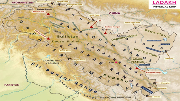 Krishen Kemmu Krishen Kemmu
There are five major mountain ranges in Ladakh. The mountain ranges in this region were formed over a period of 45 million years by the folding of the Indian Plate into the stationary landmass of Asia. Himalayas were formed from the base material of the Indian plate.
The Great Himalaya Range: The great Himalayan range features around 30 peaks including the Mt. Everest and the Kanchunjunga, two of the highest peaks. It forms the southern boundary of Ladakh, separates India from the rest of Asia and plays and important role in shaping the climate of this region. It acts as a climatic barrier, separating Ladakh from the monsoonal influence of the Indian plains. It is also important for hydrological significance as it feeds rivers like the Indus.
The Pir Panjal Range: Extends into the western parts of Ladakh. Composed of sedimentary rocks and rich in biodiversity. Acts as a gateway to the Kashmir Valley through passes like Banihal.
The Zanskar Range: Lies to north of the great Himalayan range and the south of the Indus River in Ladakh. It forms the backbone of Ladakh stretching from the ridges beyond Lomayuru in the west and across the Zanskar region. This range is breached by the Zanskar river which flows from South to North creating awe inspiring gorges until it meets the Indus River at Nimu. Known for treks like the Chadar Trek on the frozen Zanskar River it contains rich mineral deposits and is home to isolated Tibetan Buddhist communities. The Zanskar Range consists of layers of sediment from the ocean floor.
The Ladakh Range: It lies in the north of Leh and merges with the Kailash range in Tibet. Located between the Indus and Shyok rivers. Contains important passes like Khardung La, critical for connectivity to Nubra Valley. A barren and rugged range with high-altitude deserts, the Ladakh Range has no major peaks; its average height is a little less than 6000 metres, and few of its passes are less than 5000 m. Within Ladakh it forms the northern boundary wall of the Indus valley, though when the river enters the Indian side of Ladakh at Demchok, some 250 km south-east of Leh, it is actually flowing along the foot of the northern flank of these granite mountains, which it crosses by a great gorge close to its confluence with the Hanle River.
The transition between the Great Himalayan Range and the Zanskar Range as seen from a flight
The Pangong Range runs parallel to the Ladakh range for some 100 km northwest from Chushul, and extends to the south along the southern shore of the Panggong Lake. It is divided from the main Ladakh range by the Tangtse River. Its highest range is 6700 m, and the northern slopes are heavily glaciated. The Kailash Range issues southeast of the Pangong Range and continues till Mount Kailash in Ngari (in Tibet). It forms the eastern watershed of the Indus River south of Mount Sajum.
The Karakoram range: Northernmost range in Ladakh, stretching from Gilgit in the west to the Aksai Chin in the east and is nearly 500 km long. It contains more than 60 peaks having a height of more than 23000 feet from the sea level and is home to K2, the second-highest peak in the (28,251 ft). It also Includes the Siachen Glacier, a strategically significant area between India and Pakistan.
If you drive from Srinagar to Leh or from Manali to Leh, you have to cross the first major Range which falls in the way. These are the Pir Panjals. After crossing the Pir Panjal Range it’s time to now cross the big Daddy, The Great Himalayan Range itself. From the Kashmir side you do it from the Zoji La and from the Lahaul side you do it via the Baralacha La. La means a Pass in Ladakhi. After crossing the Great Himalayan Range from the Manali side and after passing over a couple of passes you need to cross the Zanskar Range and this is done at the Tanglang La. While coming from the Kashmir side you cross the Zanskar Range at Namika La and Fotu La.
And then if you want to go further North you have to go across the Ladakh Range which is crossed over at the famous Khardung La and now you come face to face with the most perpendicular of all the Mountain Ranges in the World, The Karakorams. Standing atop the Khardung La you can see the difference. The nicely rounded Peaks of the Zanskar and Ladakh Range in deep contrast to the craggy towers of the Karakorams.
Traditionally the Indus has been considered the dividing line between the Karakorams and the Himalayas. The Ladakh Range is considered by some to be a part of the Karakorams. Even the Encyclopaedia Britannica says it is a part of the Karakorams but a majority of researchers consider it a part of the Himalayas as the Ladakh Range (and its sub Range the Changthang Range) along with the Kailash Range and the Nyeng-Chin-Thanla Range run almost parallel to the Great Himalayan Range all through to its Eastern extremity and hence it is considered a part of the Himalayas rather than the Karakorams. Ladakh is located within the Karakoram Range and the Great Himalayan Range. One marks the Northern Boundary the other makes up the Southern Boundary. In order to view the spectacular Great Himalayan Range you have to come down to Kargil and head into the Suru Valley. It is here in the Suru Valley sandwiched between the Zanskar Range and the Great Himalayan Range where you get spectacular view of the Great Himalayan Range with its craggy Peaks quite different from the ones of the Zanskar or the Ladakh Range. You get great views of the Karakorams from the Khardung La.
These mountain ranges make Ladakh one of the highest inhabited regions in the world. The ranges are rich in geological and cultural significance. They also influence the climate and biodiversity of the region. These majestic ranges not only add to Ladakh’s breathtaking beauty but also define its unique geography and lifestyle.
(The author is a columinist and respected KP leader) |
|
|
|
|
|
|
|
|
|
|
|
|
| |
| |
|
|
|
|
 |
|
|
|
|
|
|
|
| |
|
All Rights Reserved � 2006-2012 early Times Newspaper Jammu. Site Designed & Developed by  |
|
|