news details |
|
|
| HIGH ALTITUDE PASSES OF LADAKH | | | 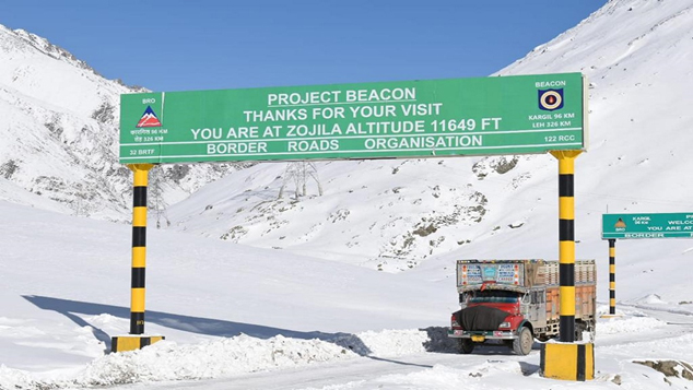 Krishen Kemmu Krishen Kemmu
The UT of Ladakh has some of the highest altitude motorable roads in the world and the bikers find these most challenging. That’s why you will find hundreds of motorbikes from all around the country and the world, in groups of 20-30 in full gear traversing the length and breadth of Ladakh. Ladakh is a paradise for the bikers.
Chang La is a high mountain pass in Ladakh at an elevation of 5,391.3 m (17,688.000 ft) in the Greater Himalaya range between Leh and the Shyok River valley. The Chang La, on Leh to Pangong Lake road, lies on the Leh-Karu-Sakti-Zingral-Chang La-Durbuk-Tangtse-Pangong Lake motorable road. Karu, which lies on Leh-Manali NH-3, connects Chang La and Pangong Lake to Leh and the rest of India. Chang La is approached from Zingral village by a steeply climbing asphalt road which requires a careful drive. The stretch of 10–15 km road on either side of Chang la becomes loose dirt and slush after the winter and requires regular maintenance. During the summer months specifically the tourist season, small streams appear across the road, making the climb a challenge for the bikers. The descent from Chang La towards Tangtse or Darbuk is again very steep. Doctors advise that staying at the top for more than 20-25 minutes can cause altitude sickness.
The Changla Pass is the main gateway for the Nubra region. The small town of Tangste is one of the nearest settlements. Zingral is the nearest habitation. The world’s highest research station, established by the Defence Research and Development Organisation is functional in Chang La at a height of 17,664 ft. Renowned for being the third highest motorable mountain pass in the world, Chang la presents beautiful views not only because of the natural landscape but also because of the yak rides and the army tea stalls in the region. It is also gateway to Pangong Tso Lake and is known for its harsh weather and strategic importance in connecting border regions.
Khardung La or Khardung Pass is a mountain pass in the Leh district of the Indian union territory of Ladakh. The pass is on the Ladakh Range, north of Leh, and connects the Indus river valley and the Shyok river valley. It also forms the gateway to the Nubra Valley, beyond which lies the Siachen Glacier. A motorable road through the pass was built in 1976, and opened to public in 1988. The pass is strategically important to India as it is used to carry supplies to the Siachen Glacier. The road is one of the world’s highest motorable roads. It connects Leh with Nubra Valley and is essential for logistics to the Siachen Glacier. Its also a major point of tourist attraction.
Khardungla in 2025
Khardungla in 1920
The elevation of Khardung La is 5,359 m (17,582 ft). Khardong La lies on the historically important caravan route from Leh to Kashgar in Central Asia. About 10,000 horses and camels used to take the route annually, and a small population of Bactrian camels can still be seen at Hunder, in the area north of the pass. Leh is on a historic caravan route that leads not only to Yarkand in Sinkiang but to Lhasa in Tibet. It was central to trade route in the ancient times. Wool, silver, felts, tea, candy, skins, velvets, silk, gold, carpets, musk, coral, borax, jade cups, salt came down from the north. Cotton goods, shawls, brocades, opium, indigo, plumes, shoes, pearls, ginger, cloves, pepper, honey, tobacco, sugar cane, barley rice, wheat, corn came up from the south.” During World War II there was an attempt to transfer war material to China through this route.
Umling La or Umlung La is the highest paved road and mountain pass in the world, located in Ladakh, India, on the ridgeline between Koyul Lungpa and the Indus River near Demchok It forms the source for the Umlung stream that drains into the Indus and a tributary of the Kiungdul river that drains into Koyul Lungpa. The Umling La pass is traversed by a road between Chisumle and Demchok, also called the Umling La Road, which ascends to a height of 5799 metres (19024 feet) in the vicinity of the pass, making it the world’s highest motorable road.
It is higher than Mount Everest’s South Base Camp, which is at 17,598 feet (5,364 m), and over half the cruising altitude of commercial jet airlines. The environment poses severe challenges for construction, with winter temperatures falling to −40 °C, and oxygen levels 50% lower than at sea level. Umlingla connects the Chisumle and Demchok villages near the Indo-China border.
Zoji La is a high mountain pass in the Himalayas. It is located in the Ganderbal district of Jammu and Kashmir and the Kargil district of Ladakh. This pass connects the Kashmir Valley to its west with the Dras and Suru valleys to its northeast and the Indus valley further east. National Highway #1 between Srinagar and Leh in the western section of the Himalayan Mountain range traverses the pass. Its close proximity to Sonamarg adds to the popularity of the pass, and you can easily combine a visit to both places in one trip if you feel so inclined.
Zoji La connects Kashmir Valley to Ladakh and is vital for economic and strategic connectivity, especially in winter when Ladakh is cut off. It falls on the Srinagar-Leh Highway (NH1) and the altitude is 3,528 metres (11,575 feet)
Rohtang Pass (Rohtang, literally meaning “pile of corpses”) is a high mountain pass (elevation 3,980 m (13,058 ft)) on the eastern end of the Pir Panjal Range of the Himalayas around 51 km (32 mi) from Manali in the state of Himachal Pradesh, the pass serves as a vital link between the verdant Kullu Valley and the arid, high-altitude regions of Lahaul and Spiti Valleys of Himachal Pradesh, India. Known for its dramatic topography and stunning panoramic views, Rohtang Pass attracts travellers, photographers, and nature enthusiasts from across the world. The journey to the pass itself is marked by a striking contrast—lush green hills gradually giving way to rugged, snow-clad peaks and barren alpine terrain.
The pass provides a natural divide between the Kullu Valley with a primarily Hindu culture (in the south), and the arid high-altitude Lahaul and Spiti valleys with a Buddhist culture (in the north). The pass lies on the watershed between the Chenab and Beas basins.
Wari la: Wari la is considered to be the 4th highest motorable pass in the world. It connects Leh to Nubra Valley. It is an alternative way to reach Nubra Valley. Usually, the people of Ladakh use the Khardungla Pass to reach Nubra Valley. The altitude/Height of Wari la Pass is 5,312 meters (17,427 feet) above sea level, which is why riders from across the globe want to ride on the road of this pass.
As the elevation of the place goes up the oxygen level goes down, the elevation of Warila Pass is 5,312 meters (17,427 feet) above sea level. That is why the oxygen level of Wari la Pass is around 50% (quantity of oxygen molecules per breath. The concentration of oxygen at Wari la Pass is dangerous if you’re not properly acclimatized before visiting this place. Staying more than 15 to 20 minutes can increase the chances of Acute Mountain Sickness (AMS).
Rezang La is a mountain pass on the Line of Actual Control between Ladakh and the Chinese-administered Spanggur Lake basin. The pass is located on the watershed ridge of the Chushul Valley, on its east. China claims that the ridge is the boundary between the two countries, while India’s claim line is further east. About 3 km southeast of Rechin La on the same ridge is a pass leading to an adjacent valley, which China recognizes as Rezang La.
This pass that was the site of a major battle of the 1962 Sino-Indian War. The “C” Company of India’s 13 Kumaon battalion, made of Ahir soldiers, fought to the last man in an effort to block the Chinese PLA troops from crossing the ridge into the Chushul Valley. Indian sources state 120 men killed over 1500 PLA troops out of 3000. The battle was the last event of the Sino-Indian War, as the pass was the Chinese claim line and upon overrunning the ridge, a ceasefire was called.
During the 2020–2021 China–India skirmishes, Rezang La was again the site of conflict between the two nations.
Bara-Lacha La: Nestled at a height of 15,910 feet, Bara Lacha La Pass is one of the most ancient mountain passes in Ladakh. It is located in the Zanskar range and links the Lahaul district in Himachal Pradesh to the Leh district in Ladakh. A prominent spot for bikers, especially those on a thrilling Ladakh bike trip, it offers beautiful views of the Bhaga River. It also serves as a pit stop for trekkers who commence their treks to Suraj Tal and Chandra Tal.
It is a heaven for bird watchers, and you can see rare and exotic species like lammergeier vultures, horned larks, wagtails, black redstarts and snow pigeons here. Bara Lacha La Pass remains open for tourists from April to October.
Lungalacha La or La Chungla (5,059 metres/16,600 feet): Located on the NH 3 Leh Manali Highway, Lungalacha La Pass is famous as one of the easy-to-climb mountains passes in Ladakh. At a height of 16,600 feet, this pass in the Zanskar range separates the valleys of Tsarap Chu and Tozay. The pass offers a spectacular view of the rugged terrain and the secluded villages. You can marvel at the gorgeous landscape surrounding the pass that is adorned with Buddhist prayer flags. It is one of the popular passes for trekkers and bikers. If you are not properly acclimatised, you may face high altitude sickness due to the height of this pass. The pass remains accessible between late May to mid-October.
Altitude: 5,059 metres (16,600 feet)
Taglang La (5,328 metres /17,480 feet): Taglang pass is located on the way from Debring to Gya and promises awe-inspiring views of the rocky Ladakh mountains crisscrossed by sparkling streams of River Indus. This stunning pass is often a favourite stopover during a Ladakh group trip, where travellers can indulge in photography and soak in some serene moments while the fresh mountain air brushes their cheeks. At the pass, you can get a glimpse of local culture in nearby villages like Sarchu and Upshi. Make sure you capture the panoramic views of the Zanskar and Ladakh ranges. It is traversed by the Manali Leh Highway and remains open between April to June.
Pensi La (4,400 metres/14,436 feet): Also known as the “Gateway to Zanskar”, Pensi pass is one of the important mountains passes in Ladakh. This mountain pass connects the Suru valley to the Zanskar valley and also acts as a watershed destination for the Suru River. This pass is essentially the beginning of Ladakh on the Srinagar route, and you can perceptibly see the landscape change hereon. The pass is situated close to Kargil and you can combine visits to the two together. A lovely glacial lake and the Drang Drung Glacier also lie at close range to the Pensi La. Rangdum Monastery lies approximately 25 kilometers away from this pass.
Namika La (3,700 metres/12,139 feet): One of the most prominent mountain passes in Ladakh, Namika La is the “Pillar of the Sky Pass.” it offers breathtaking views of the neighbouring peaks. The pass falls en route to the Mulbek valley and is a popular tourist stopping point on the way to Ladakh. There is a lot of scope for sightseeing in and around the pass. There are ancient rock carvings of Maitreya Buddha to be seen as well as a Buddhist Gompa. The pass connects Leh and Kargil and is one of the highest passes in the region. Stopping at this pass is a great way to signal your entrance into Leh Ladakh.
Fotu La (4,108 metres/13,478 feet): The highest pass on the Srinagar- Leh highway, the Fotu la is a magnificent place to visit during your trip bike to Ladakh and should be on the travel itineraries of all tourists. It is a beautiful pass and offers fantastic views of the mountainous neighbourhood. This scenic route is often a highlight for adventure enthusiasts on a Manali-to-Leh bike trip, adding thrill and beauty to their journey. Wild and chilly winds blow here all through the summer months and make the place a memorable one.
Saser La (5,411 metres 17,753 feet): A formidable mountain pass in Ladakh, Saser Laia an impressive pass and a dangerous one, and crossing it is a thrilling experience that stays on in the memory for long. The pass connects Ladakh to the Yarkand in China and provides visitors with a breathtaking experience. The roads along the pass are very rough and driving across them is not an easy task. The steepness of the pass and the low-oxygen supplies there only add to the challenge. But for those who are able to overcome these obstacles and manage a ride through the pass, the experience is rewarding. |
|
|
|
|
|
|
|
|
|
|
|
|
| |
| |
|
|
|
|
 |
|
|